Block Overview
Block type: PROCESSING
This block uses satellite imagery data and generates RGB georeferenced images using formulas provided as parameters. The output can be opened in standard images viewer and GIS tools like QGIS or ArcGIS.
Input parameters
red- the formula used for calculating values of red channel, see formulas for valid valuesgreen- the formula used for calculating values of green channelblue- the formula used for calculating values of blue channelsatellite- the name of the block providing input data, see supported blocks for valid values
The formula should be a mathematical expression containing: band names, operators and functions. More information about formulas can be found in formulas section. To see list of available bands and sample usage please visit supported blocks section.
Example parameters using Sentinel-2 Level 2 (BOA) AOI clipped block as data source and then generating false color composite:
{
  "sentinelhub-s2-aoiclipped:1": {
    "bbox": [
      19.845642734130864,
      52.30976947421495,
      19.881949734130865,
      52.32649747421495
    ],
    "time": "2018-01-01T00:00:00+00:00/2019-11-20T23:59:59+00:00",
    "limit": 1,
    "zoom_level": 14,
    "time_series": null
  },
  "qzsolutions.mixer:1": {
    "red": "B08/256",
    "blue": "B04/256",
    "green": "B03/256",
    "satellite": "Sentinel-2 Level 2 (BOA) AOI clipped"
  }
}
Output format
The block produces a feature collection with up42.data_path property containing a name of the result file.
The result file is RGB GeoTIFF with 8 bit resolution channels.
Warning
Values are expected to be between 0 and 255. Results of the formula of specific pixel will be clipped to 0 for results below 0. Values above 255 will be clipped to 255.
For most of satellites it also returns property acquisitionDate containing date of image being taken.
Contents of data.json file returned by a block configured in the previous example:
{
  "type":"FeatureCollection",
  "features":[
    {
      "type":"Feature",
      "bbox":[
        19.84130859375,
        52.308478623663355,
        19.88525390625,
        52.335339071889386
      ],
      "geometry":{
        "type":"Polygon",
        "coordinates":[
          [
            [
              19.86328125,
              52.308478623663355
            ],
            [
              19.84130859375,
              52.308478623663355
            ],
            [
              19.84130859375,
              52.32191088594772
            ],
            [
              19.84130859375,
              52.335339071889386
            ],
            [
              19.86328125,
              52.335339071889386
            ],
            [
              19.88525390625,
              52.335339071889386
            ],
            [
              19.88525390625,
              52.32191088594772
            ],
            [
              19.88525390625,
              52.308478623663355
            ],
            [
              19.86328125,
              52.308478623663355
            ]
          ]
        ]
      },
      "properties":{
        "up42.data_path":"86973862-61e8-4233-82f4-2c60049dee2e.tiff",
        "acquisitionDate":"2019-11-19T09:56:09"
      }
    }
  ]
}
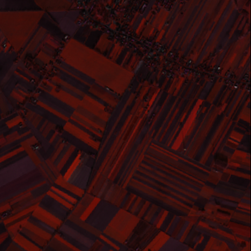
Contents of file 86973862-61e8-4233-82f4-2c60049dee2e.tiff
Capabilities
Input
This block has such input_capabilities:
"input_capabilities": {
  "raster": {
    "up42_standard": {
      "format": {
        "or": [
          "SAFE",
          "GTiff",
          "DIMAP"
        ]
      }
    }
  }
}
Warning
Please ensure that input block is listed under supported blocks link.
Output
This block has such output_capabilities:
"output_capabilities": {
  "raster": {
    "up42_standard": {
      "format": "GTiff",
      "dtype": "uint8",
      "resolution": ">"
    }
  }
}